Punakha Suspension Bridge - Truly thrilling and massive

Suspension bridges are ideal for Bhutan's high mountains and deep valleys. Punakha Suspension Bridge is a wonderful illustration of this, for the decoration of colorful prayer flags. This is one of Bhutan's longest suspension bridges. It connects Punakha Dzong to Shengana, Samdingkha, and Wangkha villages across the Po Chu river. It is, nevertheless, astonishingly stable for a 520-foot-long suspension bridge. The east side of the river is an excellent starting place for multi-day hikes in the surrounding mountains. Also, the bridge provides a beautiful view of the river and valley.

Punakha Suspension bridge in Bhutan

Which is the longest bridge in Bhutan?

Punakha Suspension Bridge is one of Bhutan's longest suspension bridges, reaching 160-180m and located high over the fast Po Chhu River. The bridge links Punakha settlement and the Punakha Dzong and is mostly utilized by inhabitants from the opposite side of town as a bypass to the Punakha Dzong.

How to get there?

Punakha Bridge is a short walk from Punakha Dzong, but because it is not on the main highway, people overlook this place. Follow the Puna Tsang Chu River north from the Dzong, through the crematorium, either by country roads on the west bank or the Trashigang-Semtokha Highway. If you are at Punakha campsite which is a mile from Punakha Dzong, cross the bridge.
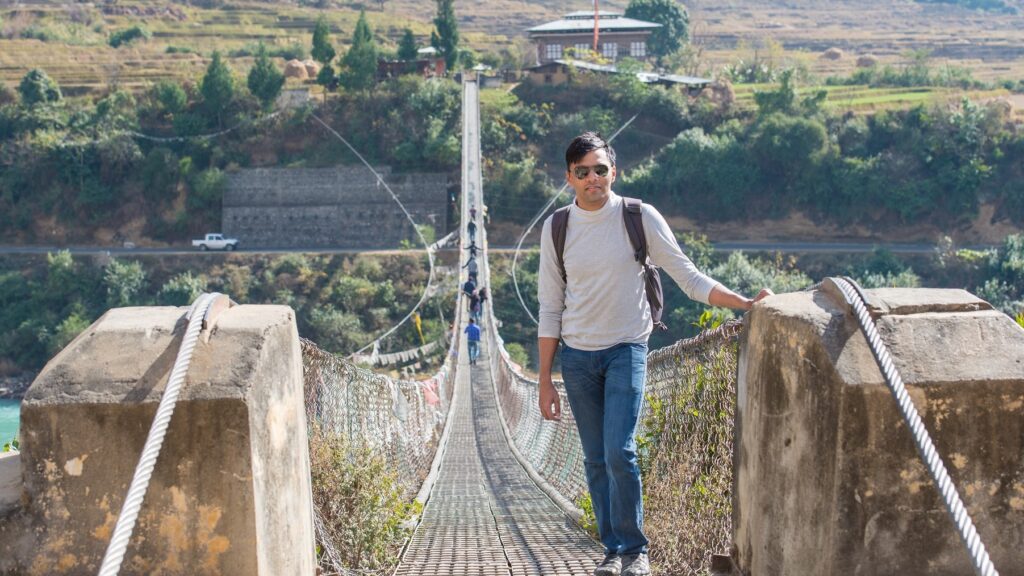
The Suspension Bridge

The bridge in front of Punakha Dzong is an excellent example of this. The bridge at Punakha, unlike the others, takes the support of cables anchored to enormous concrete slabs on the banks. The bridge's cantilever has some inherent elasticity that causes it to sway in high gusts, although not as much as you might anticipate. This is owing to the bridge's stabilizing cables, which taper out at both ends. The deck is constructed of solid wood planks that are nested within the bridge structure.

PunaTsangChu river
PunaTsangChu river

Village on the other side of the bridge

Visit the lovely village on the opposite side of the bridge. The bridge connects Shengana, Samdingkha, and Wangkha villages to the Wangchuk Kings' fortress. Apart from an exciting trek across the bridge, the bridge connects Punakha town to numerous holy and important locations worth visiting.

The best thing to do here is cross the bridge, visit the local shop and have the local tea. You get to hear the prayers, drum beats, etc from upstairs and lots many people chanting mantras. Enjoy the scenic view, have a cup of tea with the chanting mantra as your background music and then go around the prayer wheel. You can continue to explore the village further or go back to cross the bridge and visit the Punakha Dzong.

Also read: Punakha Dzong | Himalayan Kingdom of Bhutan
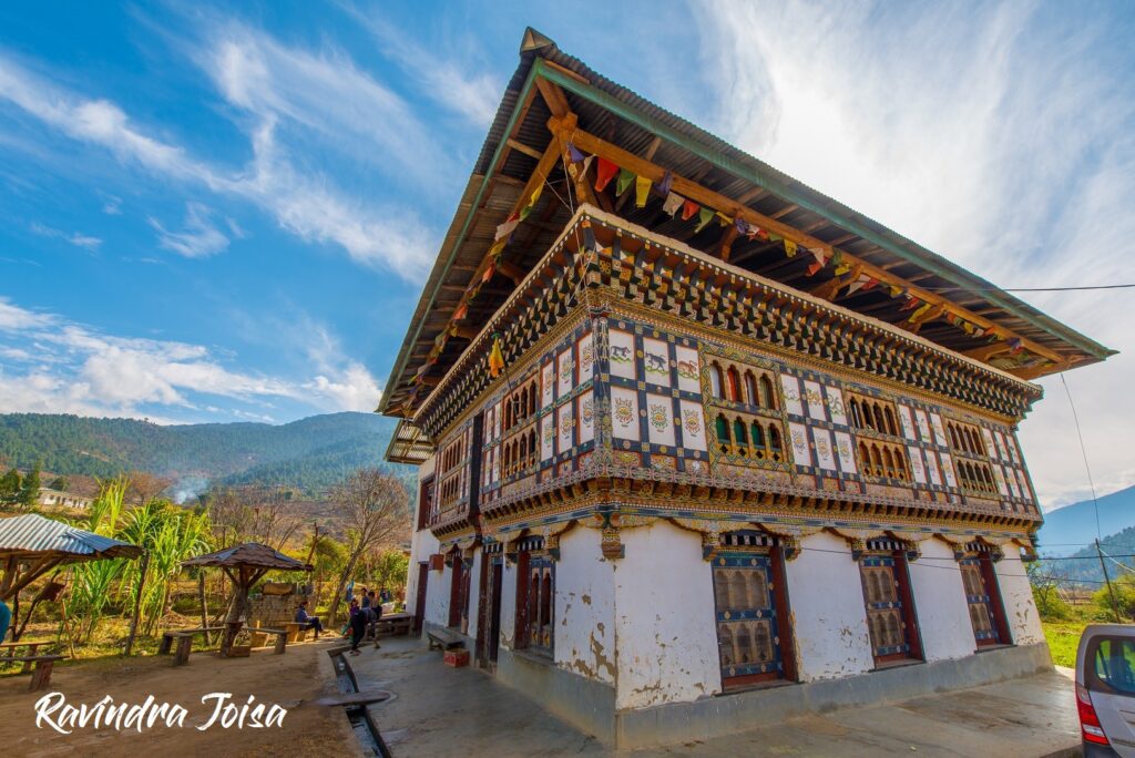
Village on the other side of Suspension Bridge

Best Time To Visit Punakha Suspension Bridge

Punakha enjoys a pleasant climate throughout the year. Visit Punakha in the months of February to April and October to December. It's best to stay away from this valley during the wet seasons, as flash floods are prevalent. Every year, the Tsechu festival takes place in late February or early March, giving it the perfect opportunity to appreciate Bhutan's spring weather and culture. The spring season, with a mean temperature of 18°C, ushers in stunning purple jacaranda blooming sceneries all down the valley.
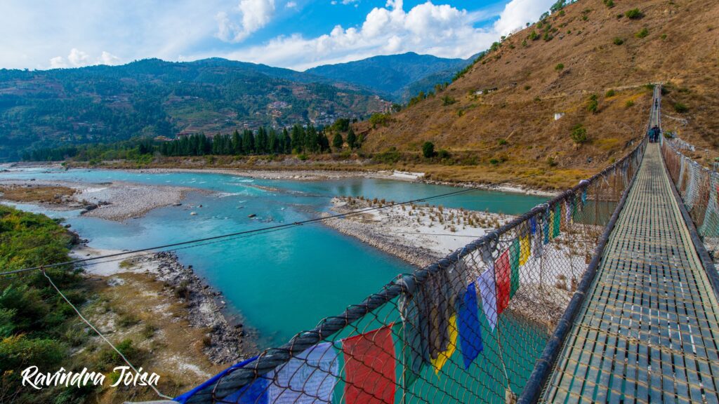
Pho Chhu Suspension Bridge Suspension Bridge

When was Punakha suspension bridge built?

Punakha Suspension Bridge in Bhutan is one of the world's oldest suspension bridges, said to have been erected by the Buddhist monk Thangtong Gyalpo. It has been refurbished several times over the years, but it was originally one of the eight bridges that served as the prototype for many of our current suspension bridges. The bridge's age is still a mystery.

To conclude, the place is unique with the walk along the longest bridge in Bhutan. The view of mountains in front and the traditional tea on the other side of the bridge makes this place interesting. Also, check the other spectacular and top 10 places to visit in Bhutan. In addition to these photos, watch the video below for more photos and to get a feel of the place in and around Punakha Suspension Bridge. Also, consider SUBSCRIBING to my YouTube channel.

https://youtu.be/Fc0by-do5Dg

Punakha Dzong - An Outstanding architectural masterpiece

Punakha Dzong - meaning 'great pleasure' or 'joy castle', is the administrative headquarters of Punakha. It is the second oldest and second largest dzong in Bhutan, and one of its most beautiful buildings. Moreover, Punakha Dzong served as the administrative headquarters until 1955.

Importance of Punakha Dzong

Punakha Dzong, located in western Bhutan, is often regarded as the country's most beautiful Dzong. In Bhutanese history, it is also the most important Dzong. The Dzong houses most of Bhutan's national treasures, and it was here that Bhutan's King, His Majesty King Jigme Khesar Namgyel Wangchuck, and his lovely bride, Bhutan's Queen Jetsun Pema, married in October 2011. The Punakha Dzong is by far Bhutan's most iconic landmark, rivaling The Tiger's Nest in Paro, so it's easy to see why it's one of the country's top three attractions, along with the Tiger Nest Monastery and Dochula Pass.

Punakha surrounded by Po Chu Mo Chu rivers

Location of Punakha Dzong

In the Punakha valley, the location of Dzong is in between the Pho Chhu (male) and Mo Chhu (female) rivers. Punakha is Bhutan's winter capital. Because Punakha Dzong is just 1,200 meters above sea level, you will not experience oxygen difficulties as you would at higher elevations such as Paro Taktsang (Tiger's Nest), making it an excellent spot to commence for beginning hikers who may experience altitude sickness in the first few days.

Punakha is also home to Bhutan's second-longest suspension bridge (Punakha Suspension Bridge), as well as Chimi Lhakhang, the Divine Madman's fertility temple, which is about 7.5 kilometers away by a vehicle. Also, visit Dochula Pass, which is midway between Paro and Punakha Dzong, to enjoy the panoramic Himalayan view. A stay further down on the banks of the river at a campsite in Punakha is a must.

That's Ravindra at Punakha Dzong

Why was Punakha Dzong built?

The significance of Punakha Dzong is that the dzong was one of the 16 dzongs erected by the Zhabdrung during his reign from 1594 to 1651 as an "embodiment of Buddhist principles." There are three docheys in the dzong (courtyards). A steep wooden draw stairway and a heavy wooden door that is locked at night are among the defensive fortifications installed in the dzong to protect it from enemy attacks. A big prayer hall was later erected after the dzong was damaged by a fire.

Punakha Dzong Architecture

Ngawang Namgyal is the mastermind behind Punakha Dzong and is Bhutan's second oldest and most magnificent Dzong. Also, It is a six-story building with a central tower situated at an average elevation of 1,200 meters against a picturesque mountainous backdrop. In addition, compacted soil, stones, and timber for doors and windows constitute the construction of the Dzong.

Six-story building with a central tower

Firstly, the Dzong was damaged by several fires and was extensively damaged as a result of the 1897 earthquake. A high wooden draw staircase and a massive wooden door are among the defensive measures that remain tall in the dzong to safeguard it from enemy attacks.

The Courtyards

Whitewashed Stupa in the first courtyard

The first courtyard houses the dzong's administrative buildings, a huge white-washed stupa, and a bodhi tree. The monks' living quarters are in the second courtyard. In this courtyard, there are two ancient halls. Also, the burials of Pema Lingpa and Ngawang Namgyal are in the third courtyard. It is located at the dzong's southern extremity.

Bodhi Tree in the first courtyard of Punakha Dzong

In the Mo Chu and Pho Chu rivers, flash floods generated by glacial lake outburst flooding in the upper parts of the valley are regular and have caused flooding and damage to the dzong in the past. Restoration is now complete with the Government of India sponsorship. The Dzong is now as magnificent as its historic times.

Inner Courtyard of Punakha Dzong

Festivals at Punakha Dzong

Domche is a yearly celebration held at the Dzong that attracts people from all around the region, including villages and outlying areas. There are some pretty magnificent performances during this five-day celebration, also known as the Punakha festival, which takes place in February/March. A re-enactment of the Tibetan invasion of Bhutan in 1639, in which the Tibetans were defeated, is a significant exhibit. Another annual rite at this dzong is the Lhenkey Dungchhur, which is a remembrance of departed spirits.

To conclude, the place has some amazing artwork, well-documented history and attracts a lot of visitors. In addition to these photos, watch the video below for more photos and to get a feel of the place in and around Punakha Dzong. Also, consider SUBSCRIBING to my YouTube channel.

https://youtu.be/uhqiYPu6Q2M

Muir Woods - Ultimate Weekend Escape from City

Muir Woods National Monument is the first significant place to be created solely as a consequence of a private land grant. This was done in order to protect redwoods, some of which are over 150 years old, from logging. Hike through the towering redwoods to understand why John Muir was such a staunch supporter of the preservation of America's most sacred places.

Muir Woods Entrance
Entrance. Picture credit: Ravindra Joisa

In the national park, there are limitless opportunities to learn and explore, from hiking to stargazing to uncovering ancient cultures. Also, the air was fresh and clean thanks to the enormous redwood trees and rich, green vegetation. I would recommend arriving early in the morning to escape the throng for the soothing and mystical sounds of nature. Moreover, the enormous redwoods towered over us, magnificent and majestic.

Ravindra Joisa at Muir Woods, ideal California weekend getaways

The Muir Woods National Monument is an old-growth coastal redwood forest, just in case you have this question in mind - Is Muir Woods the same as the redwood forest? The Bohemian and Cathedral groves contain the biggest trees – one 252 feet tall and one 14 feet wide.

How to get to Muir Woods

Muir Woods is a few miles to the north of San Fransisco, just after crossing the famous golden gate bridge. You can reach this place early morning if you have plans to visit Napa Valley, famous for some of America's vineyards.

I would recommend you to travel to this location using your own private vehicle or with a tour operator. Technically speaking, you can make use of cab services like Uber or Lyft as it is about 16 miles from Golden Gate, but returning from this place will be hard. There is no Wifi or mobile signal, so booking a cab won't be easy. Note that there is an entry fee of $ 15 for 16 years old and above.

You can't drive through Muir Woods, renting a car isn't a good idea. Because there are a limited amount of parking places at the entrance, you must book and pay for a spot ahead of time.

Redwoods trees at Muir Woods - Redwood forest
Tall redwood trees. Picture Credit: Ravindra Joisa

Weather and Camping

Muir Woods, like the rest of the Pacific Coast, is known for its pleasant weather. Temperatures in the forest vary from 5 to 20 degrees Celsius most of the year, making it the ideal weekend getaway. Although camping is not permitted within the park, there are numerous choices in the surrounding region. Hikers seeking seclusion in a redwood forest will find this place to be an ideal refuge.

Path to the bridges at Muir Woods
Empty trail early in the morning. Picture: Ravindra Joisa

How long does it take to walk through Muir Woods?

The enormous old-growth redwood trees are well-known. Trails go to Cathedral Grove and Bohemian Grove, as well as along Redwood Creek. The Ben Johnson and Dipsea paths in Mount Tamalpais State Park climb a slope for views of the treetops, the Pacific Ocean, and Mount Tamalpais. There are 6 kilometers of trails in this National Monument. There are 30-minute, 60-minute, and 90-minute loops available, as well as longer treks on trails that stretch into Mount Tamalpais State Park. View a map of Muir Woods and the surrounding area. All of these hikes have vistas of ancient redwoods, the world's tallest living objects.

Hiking Trail at Muir Woods
Hiking Trail. Picture Credit: Ravindra Joisa

Also read: Canyon Trail – River Place Nature Trail, Austin, TX

So, Is Muir Woods worth visiting? A trip to Muir Woods is definitely worth your time, especially if you won't be able to see redwood trees otherwise. The site is rather simple to navigate. Also, check out the video from Muirwood redwood forest to get an idea of how it feels to be there. In addition, support my work by subscribing to my YouTube channel.

https://youtu.be/X2j_for7qnc

Kanamo Peak Trek - 19,553 ft | Intriguing Summit Climb Attempt

It was time for the summit hike to Kanamo Peak, which stands at 19,600 feet, after spending a day in Kanamo Basecamp. Even though the weather had been awful the day before, it seemed to be fine on the summit day, and our trip leader gave us the go-ahead.
Also check: Hike from Kibber village to Mount Kanamo Basecamp

Kanamo Peak
Kanamo Peak standing tall at 19,600 feet above sea level, Kibber, Himachal, India

The terrain along the Kanamo Peak trail

This hill has a steep grade, and many people develop high altitude sickness if they are not well equipped. It is also a continuous rise to the summit, with the final seven hours consisting of a nearly vertical slope on a steep inclination entirely on scree. As there is no option to camp anywhere in between, you will have to descent back to Kanamo Basecamp which will take around 3 hours, provided everything goes as per the plan. Note that there is no water source anywhere around and the nearest water source is at Kanamo Basecamp. A proper cold weather jacket is a must at this altitude since the early morning breeze is ice cold.

Landscape around Kanamo
The landscape around Kanamo Peak

Wildlife and fossile

The summit attempt starts as early as 3-4 AM. Early in the morning, you traverse the first section of the mountain. Keep an eye out for distant mountain ranges and the sky's ever-changing golden hour colors. On the way up we could see the Wild Himalayan Yak and the Himalayan Ibex. In rare cases, you might even find Himalayan snow leopards. There are tours organized by the locals, a visit to the Kibber wildlife sanctuary during winter in the month of March.

Wild Himalayan Yak
Himalayan Yak

Buy Himalayan Yak Images from my store to support my work - 'Store'

Look for fascinating stones in this section as you go on since many of them are likely to be plant or animal fossils. There are several fossil repositories that can be found. Here is what we found - check the video below, whale and fish fossils and a few shells up in the Himalayan mountains, which were once undersea.

Himalayan Ibex
Himalayan Ibex

High Altitude Sickness

We were soon on our way to the mountain's second section. The last stage of the climb to Kanamo Peak, a hard rise of around 70-80 degrees on the scree slopes – takes about 4 to 5 hours. From here, the entire ascent is on scree. This is where I could no longer climb and could clearly see the signs of altitude sickness. Only a few could make it to the summit. I could hardly see anything around and had to almost get our trek lead's support to stand still.

Chicham village in the background on the way back from Kanamo Peak
Chicham village in the background & that's me on the way back from Kanamo Peak

Altitude sickness is dangerous and can even cause death. I did not want to take any kind of risk. I can clearly see that most of us were not acclimatized and almost half the team had the same trouble. We were now close to 18000 feet. I could hardly capture any photos here and my only aim at this time was not the summit but to get back to a lower altitude in order to recover from the altitude sickness.

Wildflowers on the way to Kanamo
Wildflowers on the way to Kanamo Peak

I finally managed to get back to KBC and spent the evening inside my tent lying still. I recovered the next morning and resumed my journey to Kibber village the following day. From here we explored the scary super adventurous ropeway ride across Parilungbo Canyon, on the way to Chicham in Spiti Valley. As of this writing, this ropeway is now replaced with a bridge, which was under construction when I visited the place. This bridge is now completed, which is the tallest bridge in Asia at 13,596 feet high.

https://youtu.be/QrSZgGiw7fc

That was my story of an attempt to climb the Kanamo Summit which is almost 70% the height of Everest. By the way, while hiking, I had come across a few who opted for Kanamo Peak trek Solo. You may hire a local guide who can also cook for you and the trek can be completed in 2 days if you are acclimatized. Hope you enjoyed watching the video. By the way, here is the camera gear that I take along when I travel. Support my work by SUBSCRIBING to my Youtube channel.