Showing posts with label Cycling. Show all posts

Discover the 3 days of Top Secret Cycling in Munnar Tea Estate Hideaways

South India's Munnar is a well-liked vacation spot with some of the best bike paths. Cycling in Munnar is a wonderful way to discover the area's stunning scenery, tea plantations, and animals. There are numerous cycling excursions offered for people of all skill levels and interests.

Ravindra - Cycling in Munnar

Youth Hostels Association of India (YHAI) offers one of the best bicycle tours of Munnar. Cycling enthusiasts of all levels enjoyed a week-long excursion that took them through rice fields, tea farms, along streams, as well as in and out of communities. Both novice and expert cyclists will enjoy the meandering roads of Munnar that pass through shola woods, cardamom fields, and tea gardens. There will be plenty of opportunities to see some unusual animals while hiking or cycling through the Marayoor Sandalwood Reserve, Thoovanam waterfalls, and Kannan Devan Hills.

Day 1 - Cycling in Munnar from Devikulam to Top Station
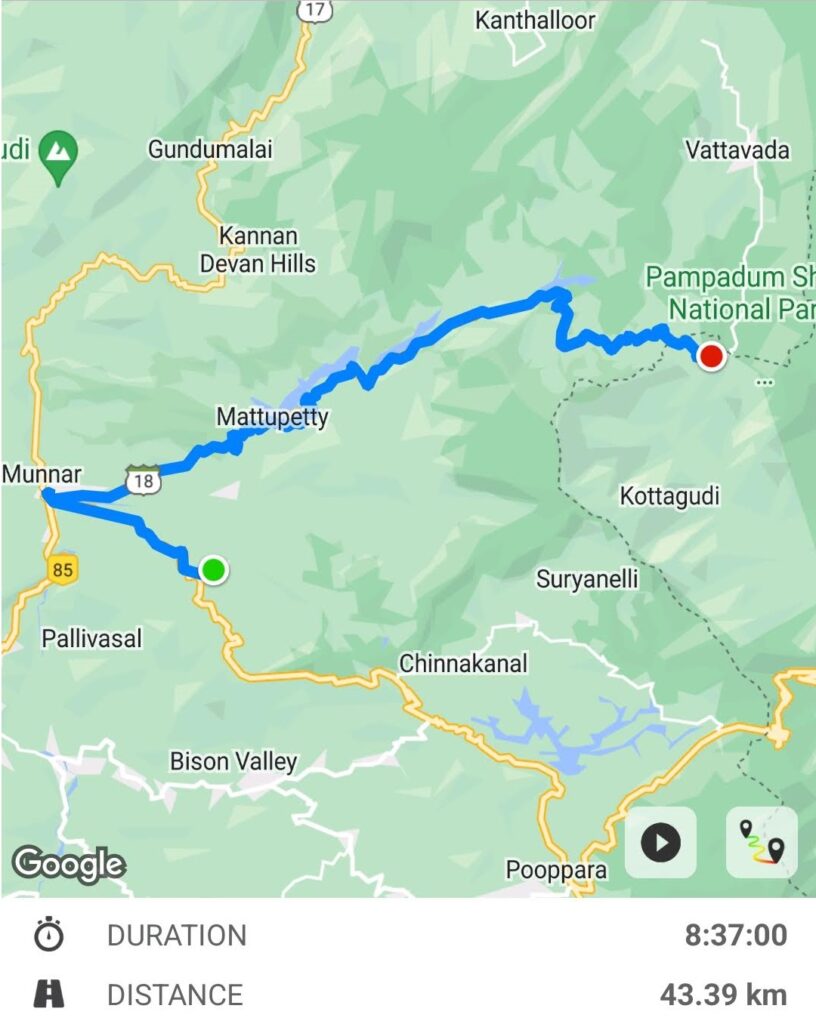
Cycling in Munnar - Map route from Devikulam to Top Station

In Munnar, cycling begins at the Devikulam Adventure Club. I rode the Firefox mountain bike as part of our Winter Cycling adventure program. This day, we rode through Munnar, covering the whole Mattupatty Reservoir bank before reaching the Top Station.
We received an introduction and information on the route we would travel the day before. We examined our mountain bikes and test-rode them on the road next to our campground. The hostel accommodations at this adventure camp were relatively modest; there were no tents. The price included the mountain bike rental, lodging, meals, and insurance.

Munnar Mountain biking

We cycled in between the tea gardens after having our breakfast and being waved off by YHAI officials; there was a climb followed by a gradual descent. Drone photography is perfect for the area. The roads are in good condition. To enter Munnar town, turn right at the end of the road. The area is congested, therefore follow the road that leads to Mattupatty Dam as indicated on the map above. When you cross the dam, you will arrive at the well-known tourist spot. There are too many shops and crowds are common throughout the winter. You may go boating, use speed boats, and participate in adventure programs.

Tea gardens in Munnar

We rode our bikes through other villages as we carried on, passing lovely tea gardens. On this particular day, we cycled around 43 kilometers on a gradually ascending path. There are multiple shops along the route, so finding food and cool drinks is never a problem. Carry a raincoat and attempt to complete the journey early in the day in case it starts to rain later. Up until we arrived at the Top Station, another well-known tourist destination, the final few kilometers were all downhill.

Cycling in Munnar on a foggy day

We slept at an accommodation close by. The next day, we tried to get to the Top Station viewpoint, a short walk away that required a ₹20 admission ticket from the forest department. However, due to the fog and low visibility, we only stayed nearby while enjoying our early-morning tea.

Meanwhile, you may want to check the YHAI - Leh - Lamayuru Cycling Expedition

Day 2 - Cycling in Munnar from Top Station to Kundali Tea Estate

Cycling in Munnar from Top Station to Kundala dam

Similar to the previous day, the first few kilometers of our ride were uphill, followed by a few kilometers downhill. The visibility was terrible and everything was hazy. We deviated from the main road and entered the exclusive tea gardens, which are only accessible to residents. We arrived at this location after passing through a few villages, and we finally came to a stop at the gated tea packing facility. Getting the go-ahead and clearance to continue required some time and a few phone calls. We kept on and passed through a few more villages before arriving at the Kundalu Golf Course.

Kundalu Golf Course
Kundalu Golf Course

Because of how beautiful the area was and how well-kept the green meadows were, we took some time to stop and take pictures. When we reached a road going to the reservoir, we turned around and proceeded on. We stopped in a quiet area to observe the Kundala Dam reservoir while enjoying our packed lunch. After lunch, because the golf course was a private place we continued cycling uphill for the next few kilometers before going downhill till we reached another tea packaging facility. There were no shops nearby, the road was in poor shape, and the region seemed to be a forest. Elephant dung and electric fencing were everywhere.

Kundala dam and reservior near Kundalu Golf Course

From here, it is a moderate ascent uphill with views of Kundala Lake along the way. We spent the night at the Kundali tea estate, which is located further down in the center of the tea gardens. The location is close to Kundala Dam, another well-known tourist destination. We had chosen the off-road path, and it had been a great decision. Keep an eye out because there are wild elephants in this area. Once you have arrived at the campsite, take a hike up the surrounding hill through the tea gardens to enjoy the sunset, lake, cloud-covered mountains, and of course the lovely tea gardens.

Day 3 - Cycling in Munnar from Kundali Tea Estate to Devikulam

Cycling in Munnar from Kundala tea estate to Devikulam

On this day, we continued our detour through a tea estate and a few villages until arriving at the main road. There will be traffic here. So, after crossing the Mattupatty Dam, we diverted from our original course and followed a different one. The trail is surrounded by tea estates but lacks any shops or villages. The highway is parallel to this path. We continued on this track, asking the locals for assistance in determining the precise path. Eventually arrived in Munnar town, then climbed steeply to the Devikulam camp.

Other places that you can visit cycling in Munnar

In addition to the three days mentioned above, you could spend some time cycling to Suryanelli while in Munnar. Suryanelli is a vacation destination in Kerala, India's Idukki district, in the Chinnakanal hamlet. It is around 50 kilometers from Munnar. It offers breathtaking views of mountains, waterfalls, and sunrises in addition to being noted for its tea and cardamom plantations. Numerous species of rare birds and other endangered creatures can be found in the forest in Suryanelli. The town is also surrounded by numerous resorts and tea plantations, making it a well-liked tourist destination.

Additionally, the prominent hospitality residential college Munnar Catering College is located in Suryanelli. Additionally, Suryanelli is not far from Tea Town Munnar, which is situated in the Upper Surianalle Estate, Devikulam, and spans 638 hectares of tea plantation. The proximity to Annaimudi, the highest peak in South India, and the Eravikulam National Park, famous for the Nilgiri Thar, adds to the pure aspect of these hills. It is the highest tea-growing region in the world. The other place to cycle and enjoy the landscape would be Pumbarai.

Where to stay in Munnar?

There are several options for accommodation in Munnar ranging from budget-friendly hotels to luxurious resorts. They will take care of your stay if you chose to go cycling in Munnar with YHAI, but keep in mind that their accommodations are modest. You can choose from hostels in the heart of a tea estate to luxury resorts in remote locations. I advise staying at a hostel if you are traveling alone, whereas resorts are an option for individuals who do not like adventure or are traveling with families.

How to take part in Winter Cycling in Munnar adventure program

The Munnar Winter Cycling adventure lasts for five days. Since this is a youth hostel program, do not expect luxury. Keep in mind that to participate in YAHI activities, you must be a member of YHAI and be an Indian citizen. The cycling event will cost about ₹9,000 as usual, which includes everything. The facilities could have been better. The mountain bike rental fees are covered. On the day of reporting, you must also turn in your medical certificate and admit card. With the membership card, you can take part in events like - 10-day YHAI Goa Trekking – An Extraordinary inspiring hike to the unknown.

How to reach Munnar

By air: Cochin International Airport, located around 110 kilometers from Munnar, is the closest airport. An additional choice is 140 km away from Madurai International Airport. You may easily take a taxi or cab from either airport to travel to Munnar.

By train: Aluva, which is situated about 110 kilometers from Munnar, is the closest railway station. From large cities like Mumbai and Bangalore, you can take a train to Aluva and then take a cab, a public bus, or a state-run vehicle to get to Munnar.

Driving in Munnar

By road: State government public transportation buses connect Munnar to other cities in Kerala and Tamil Nadu. Numerous tour operators also plan pre-packaged bus excursions from Cochin to Munnar. To go to Munnar, you can also take a bus from cities like Kochi, Thrissur, Madurai, and Thiruvananthapuram. There are also plenty of private taxis and cabs available. Also, self-drive cars are available in cities like Bangalore or you can get your own vehicle, which is exactly what I did and went around. You may even mount your cycles on top or back if you are interested in cycling in Munnar.

Before you go on a hike or cycling make sure to check this out – some of the Absolutely mandatory Hiking Accessories to carry. So, that was my experience of cycling to this place. Hope you enjoyed reading this blog post. Buy me a coffee to support my work or you can go to my store to buy some of my images. Also, do not forget to join my FriendZone by signing up for my newsletter. Consider subscribing to my YouTube channel.

Cycling Expedition crossing highest pass with an incredible landscape in 5 days

This is a weeklong Himalayan high altitude mountain biking or cycling expedition organized by the Youth Hostel Association of India. There are many youth hostel India national programs every year and this is one among them. The experience that you gain is something incredible.

YHAI National Himalayan Mountain Biking Leh itinerary

(LEH-LAMAYURU - SKURBUCHAN - SAKAR-2 - HENISKOT - FOTULA PASS - LAMAYURU - LEH
Day-01: Reporting At Leh (11,500 Ft.) (Jimmy Guest House)
Day-02: Acclimatization & Orientation (Transfer To Main Base Camp Lamayuru)
Day-03: Equipment Distribution & Bike Trial Riding
Day-04: Ride to Skurbuchan (43 Km, 9750 Ft,)
Day-05: Ride to Sakar-2 (38 Km, Via Sanjak, 10.550 Ft)
Day-06: Ride To Heniskot(Chulungthan) (25 km.Via.Khangral ,11.400 Ft)
Day-07: Ride to Lamayuru ( 27 Km, crossing Fotula Pass 13,450 Ft. )
Day-08: Transfer to Leh Camp.
Day-09: Camp breaks after Breakfast (09-00 a.m.)

Leh to Lamayuru - Day 1

Day one of the mountain biking expedition in Leh was more of travel from the main base camp at Leh to Lamayuru camp (starts from day 3 in the above itinerary list). On reaching Lamayuru camp we practiced for a while and went for an acclimation ride at Lamayuru village, just before sunset. The national mountain biking expedition event organized by the youth hostels association of India, YHAI is exceptionally good. Read More on - Leh to Lamayuru mountain biking.

Mountain Biking at Leh by Ravindra Joisa

Moonland to Skurbuchan – Day 2

Day two of the mountain biking expedition is from Lamayuru to Skurbuchan via Domkhar. The first 5 kilometers are all downhill, covering Moonland and multiple hairpin curves. The rest of the route is all flat, on the banks of the Indus river. We stopped at Domkhar for lunch and visited the Rock Art sanctuary. Post lunch we continued our cycling all the way to our next campsite at Skurbuchan. More on - Lamayuru to Skurbuchan

Cycling expedition at Leh by Ravindra Joisa

Skurbuchan to Shakar via Sanjak– Day 3

Day three of our cycling, from Skurbuchan to Shakar was another exciting one. Cycling next to the Indus river, the amazing landscape, cycling through the apricot farmland, river crossing, cycling next to the stream, cycling downhill and extremely tiring uphill followed by camping next to the stream. More on - Skurbuchan to Shakar

Ravindra Joisa Leh indus river Mountain Biking

4000 years old Domkhar Rock Art Sanctuary

Domkhar rock art sanctuary is located at Domkhar village in Leh, next to the banks of the Indus river. The place is known for artwork that was made by travelers in pre-historic times. People in this region grow apricot and apple, which is the main source of income. This place is for those who love the historic artwork by our great ancestors. There are numerous rock-carved figures, thought to date back between 2000 and 4000 years.

Ravindra Joisa Leh Mountain Biking adventure

Sakar to Haniskot – Day 4

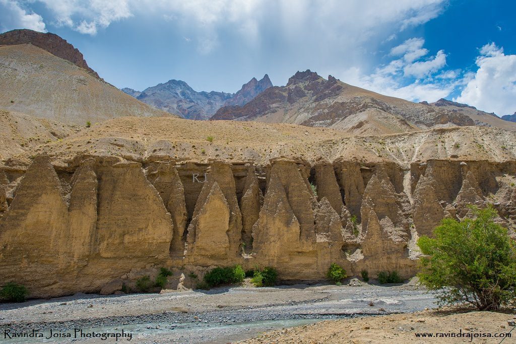
Our stay in a guest house next to the stream at Sakar was great fun. We explored the place and started cycling, crossing small villages, till we reached national highway 1. The landscape around is so beautiful and looks like a painting with high contrast. The landscape is so unique, the soil erosion forms unique structures, untouched by humans. The mountains in the background, the green patch in between, and the river in the foreground look very much like the one from our primary school painting class textbooks. On day 4 we covered a distance of 38 kilometers from Sakar 2 to Haniskot via Sanjak. More on Sakar to Haniskot

Ravindra Joisa Leh Mountain Biking Highway

Kanji – An Extraordinary village with some amazing people

Kanji is a Himalayan village that is incredibly secluded. The settlement is roughly 12 kilometers from Haniskot, which is located on the NH1 Kargil-Leh route and is only accessible for four months of the year. Kanji is well-known for its harsh scenery and the perilous path between Haniskot and Kanji. More on this remote village Kanji.

Ravindra Joisa Leh Mountain Biking

Haniskot to Lamayuru via Fotu La - Day 5

The first half of the day is all uphill cycling all the way to Fotu La (pass) also called TV tower. The view from this place is breathtaking. It was drizzling and was super cold. From here it is all the way downhill to Lamayuru with a viewpoint in between. It was so cold that my fingers were numb, literally frozen, and couldn't even change gear while riding. Did not have to press hard on pedals as it was all downhill. By the way, Fotu La s the highest point in this high altitude mountain biking expedition organized by the YHAI - Youth Hostel India.

Ravindra Joisa Leh Mountain Biking Haniskot

Mountain Biking video playlist

Here is the complete playlist of High altitude mountain biking or the Lamayuru cycling expedition. You will get a feel of how the place is and how enjoyable the place is, showing some of the extreme landscapes.

https://youtube.com/playlist?list=PLBtUUJUvar6rgtkL-WsWPY4t3ni4pgCIc

Mountain Bikes used

If you are with Youth Hostel then the gear cycles or MTBs will be provided and is part of the fee that you pay. Else, here are some of the mountain bikes that I would recommend - Firefox, Decathlon BTWIN, Polygon. I have been using Polygon and you may want to check how good it is in the blog post Cycling at Turahalli Forest.

Here is a playlist that I have created for each of those days and the 2 off-track places that we covered. One of the best cycling expeditions I have ever been to and made many new friends.

That’s was my experience of traveling to this place. Hope you enjoyed reading this blog post. Buy me a coffee to support my work or you can go to my store to buy some of my images. Also, do not forget to join my FriendZone by signing up for my newsletter.

Battling the highest pass of Fotu La - Cycling Expedition - Day 5

The first half of the day is all uphill cycling all the way to Fotu La (pass) also called TV tower. The view from this place is breathtaking. It was drizzling and was super cold. From here it is all the way downhill to Lamayuru with a viewpoint in between. It was so cold that my fingers were numb, literally frozen, and couldn't even change gear while riding.

Did not have to press hard on pedals as it was all downhill. By the way, Foto La s the highest point in this high altitude mountain biking expedition organized by the YHAI - Youth Hostel India. By the way, currently the program is known by the name Lamayuru Cycling Expedition.

Lamayuru campsite

Exploring Haniskot and Kanji

We had arrived in Haniskot the day before from Sakar and slept overnight in the Haniskot government guest house, which was still under construction at the time of my visit. We visited a secluded village called Kanji because we arrived early and had plenty of time to explore. It is a unique community filled with monasteries and kind people. If you're in Haniskot, you should definitely pay this establishment a visit.

Haniskot to Fotu La, Lamayuru cycling expedition

Cycling uphill to Fotu La

The climb uphill to Fotu La had consumed all of our time on this particular day. The terrain is arid and seems desert-like, and the intense light may quickly tan your skin. Fortunately, the brilliant blue sky turned gloomy within an hour of leaving Haniskot. This made our uphill riding less strenuous. On the ride up to the Fotu La TV tower, there were a few little stores selling cool beverages and snacks.

Near Fotu La, Lamayuru in the national highway one.
Pass Crossing near Fotu La

By the time I got to the top, what had started as a drizzle had developed into severe rain. I was absolutely soaked, and the very cold weather made uphill riding and gear switching much more difficult. As you can see in the video, there is no protection of any type at the pass, so I had to seek cover behind a truck and begin my descent swiftly despite the rain.

Fotu La, also known as Fatu La, is a mountain pass on the Srinagar-Leh route in India's Zanskar Range in the Himalayas. It is the highest point on the roadway, at 4,108 metres, exceeding the famous Zoji La. Fotu La is one of two high mountain crossings that connect Leh and Kargil. The other is Namika La.

https://youtu.be/LybQElP1irk

Lamayuru Moonland of Ladakh

Lamayuru cycling with Youth hostel
Cycling at Lamayuru

When you gaze at the distinctive terrain of Lamayuru, it is both enchanting and amazing. This is commonly referred to as the 'Moonland of Ladakh' or simply Lamayuru Moonland. It is located in Lamayuru, a community located around 100 kilometres from Leh on the Kargil-Leh route. The moon-like terrain is unusual and is thought to have been formed by the drying of a large lake. We were ecstatic because it looked stunning, and for a little minute, we thought we were in an other nation.

Lamayuru Moonland
Moonland, Lamayuru, Ladakh, India

The landscapes on the journey from Leh to Lamayuru are breathtaking, and we wanted to stop at every moment. Lamayuru is also well-known for its ancient monastery. Some pieces are in fair shape, while others have been well kept. There are just a few homestays here, and one of them is directly outside the monastery gate. Needless to say, the view from the monastery and on the route up to the monastery is spectacular. Further down the road, is a ground where we camped. After completing the Lamayuru cycling expedition, we attempted the Zanskar river rafting, wich was even more adventurous where one of our rafts capsized.

Leh cycling expedition Lamayuru campsite
Lamayuru Camp

That’s was my experience of traveling to this place. Hope you enjoyed reading this blog post. Buy me a coffee to support my work or you can go to my store to buy some of my images. Also, do not forget to join my FriendZone by signing up for my newsletter.

Kanji - An Extraordinary village with some amazing people

Kanji village - Leh - Haniskot

Kanji is a Himalayan village that is incredibly secluded. The settlement is roughly 12 kilometers from Haniskot, which is located on the NH1 Kargil-Leh route and is only accessible for four months of the year. Kanji is well-known for its harsh scenery and the perilous path between Haniskot and Kanji.

Kanji photo by Ravindra Joisa

How to reach Kanji?

Kanji is 12 kilometers away, and the only route to getting there is through the settlement of Haniskot. Haniskot is located on National Highway One, which connects Kargil and Leh. Haniskot and Kanji are connected by a tar road. The road is part of India's PGSY (Pradhan Mantri Gram Sadak Yojana). The location is close to Foto La (pass) and Lamayuru. The location is great for a long weekend trip from Leh or for people who wish to ride their bikes about.

Route to Kanji Village

The route begins with a sharp downhill, followed by a 10-degree gentle ascent all the way to Kanji. Even though significant rain is exceedingly unusual in this region, the roadways are narrow and prone to landslides. The roads follow a stream (which appeared to be more of a river) all the way to the settlement.

The village Kanji

Kids from Kanji village

The majority of the population in this area are Buddhists, and there are three monasteries. There is only one food store and one Tea shop. There are 52 homes and a primary school in total. Despite the fact that this area is buried in thick snow for six to eight months of the year, agriculture is the major profession in this area. Fortunately, this location is now connected by an excellent road, which serves as a lifeline. Lovely folks to converse with, and the high school students like playing cricket.

There are numerous antique, traditionally constructed structures in the area. The Tibetan culture has had a strong effect on the community, as seen by the clothing. The community ensures that no political or religious pressures interfere with their way of life.

When I visited this location, I mostly saw seniors and young children playing cricket on the village road. The majority of the middle-aged males commute to adjacent towns such as Lamayuru during the week and return home on weekends or late at night.

Senior Citizen at Kanji village

I happened to visit this place during my National High Altitude Mountain Biking Expedition in Leh conducted by the Youth Hostel Association of India. This was an off-route visit. As we reached the campsite at Haniskot by lunchtime and had enough time to explore, we took our mountain bike to this beautiful little-known village of Kanji.

Hotels to stay

In this village, there may be fewer places to stay. You may have to camp in a tent or there may be a few houses stays available today. People are nice, so you may even ask for the locals. Another alternative is to stay in the Haniskot Government Guest House. Hotels in Lamayuru may be found if you walk farther, once you cross the Foto La TV tower and proceed all the way down. It is a little village that attracts travelers. Lamayuru is well-known for its lunar landscape and monasteries.

https://youtu.be/S27trVnk6PI

To summarise, this distant location Kanji is a must-see if you want to witness severe roads, a lonely community, and camping near to an agricultural area. There will be no telephone network, power, gas, or water supply. Water should not be an issue. There were government efforts underway to deliver power to this location, as well as an optical fiber project. This is an excellent location for anyone going by bike, vehicle, or campervan. Because many people are unaware of its existence, it does not receive a large number of visits. Watch the movie below to get a sense of my trip to this location, and don't forget to subscribe to my channel.

Stunning and scenic landscape from Shakar to Haniskot - (Leh Mountain Biking - Day 4)

Our stay at a guest home beside the creek in Shakar was fantastic. We toured the area and began cycling on the Khangral-Sanjak route, passing through tiny villages until we reached National Highway One. The surrounding countryside is stunning, resembling a high-contrast picture. Because the area is so unique, soil erosion creates unique structures that have been unspoiled by people. The mountains in the backdrop, the green area in the middle, and the river in the front all appear to be from our elementary school painting class textbooks. On day 4, we traveled 38 kilometers from Shakar 2 to Haniskot.

Sakar to Haniskot

Previous days of cycling to this place

Day1 – Leh to Lamayuru

Day2 – Moonland to Skurbuchan

Day3 - Skurbuchan to Shakar

Shakar to Haniskot

Shakar to Haniskot - Leh Mountain Biking

Exploring Shakar Market road and campsite

Shakar is a lovely campground located near a brook that flows into the Indus. We stayed in an under-construction government guest house named the Tourist Facilitation Centre and spent the evening touring the campground and the surrounding Shakar market road hamlet. It is frequently chilly at night, making it a great location for a bonfire. Investigate the communities in and around Shakar. Try something different in Shakar, such as butter tea or local bread, and stay in one of their houses; after all, it is a one-of-a-kind experience. Make friends with the locals; they can be fantastic portrait subjects if you enjoy portrait photography or wish to film a documentary.

Khangral - Sanjak road

Cross the river across the bridge and continue on the Khangral-Sanjak route we took on day three. As we ride through villages and fields, there are several stores. We get to travel through the green patches and agricultural regions adjacent to the river and the dark multi-hued brown mountain peaks. Continue cycling up and down the mountain, following the Khangral-Sanjak route until you reach National Highway One at Khangral. Take a left at this crossroads, which will lead you to Leh. The road to the right will lead you to Kargil and Srinagar.

National Highway One - Shakar - Leh Mountain Biking

Stay at Haniskot

The most picturesque path is to the left. There are a few little stores along the road where you may stop and enjoy the scenery. Continue cycling till you reach Haniskot, another gorgeous location. Cycling here isn't difficult; just a few ups and downs might be difficult in the sweltering midday sun. Take a rest at one of the surrounding stores on your trip to Haniskot. The scenery is stunning, and it's an excellent location for taking photographs. Finally, we remained at the government bungalow/guest house, which was conveniently located adjacent to the highway.

A visit to remote village Kanji

A kilometer from this bungalow is a road to the right that takes you to a place named Kanji which is about 12 kilometers from the junction. The journey to this location is beautiful. The YHAI itinerary does not include a visit to Kanji. We arrived at Haniskot much early, and it was up to us to explore. A few of us who had the energy went a little further. The entire distance between Kanji and Tokyo is around 26 kilometers.

https://youtu.be/VfEzqrgVdfM

This cycling expedition was organized by the Youth Hostel Association of India and as you are reading this post, and interested in outdoor activities then check out the National trekking expedition in Goa. To get a sense of the location, watch the video above. Hope you enjoyed reading this blog post. Buy me a coffee to support my work or you can go to my store to buy some of my images. Also, do not forget to join my FriendZone by signing up for my newsletter and SUBSCRIBE to my YouTube channel.

Skurbuchan to Shakar - (A wonderful cycling experience on day 3)

Day three of our cycling, from Skurbuchan to Shakar was another exciting one. Cycling next to the Indus river on Indus valley road, the amazing landscape, cycling through the apricot farmland, river crossing, cycling next to the stream, cycling downhill and extremely tiring uphill followed by camping next to the stream.

Ravindra Joisa at campsite Mountain Biking

Check out the first two days of our cycling here

Day1 – Leh to Lamayuru

Day2 - Moonland to Skurbuchan

Where to stay in Skurbuchan?

If you are traveling solo to this beautiful remote village in Skurbuchan then you might want to consider staying at homestays at Aryan valley. There are places where you can camp and on the way you will find small shops where some of the rations are available which is good enough if you are planning to camp. Also, there is a government guesthouse. Watch this video below to know more.

About Skurbuchan

Skurbuchan village is located above the Indus in western Ladakh, approximately 125 kilometers from Leh. The name of the settlement comes from a native fruit called 'Skyur,' which is exclusively cultivated in and near the village. The village, with a population of over 2000 people, is one of the largest in the region. Beautiful river streams, lush green meadows, and delightful walks make this settlement a perfect addition to any Ladakh itinerary. The settlement boasts a big Buddha statue on a mountaintop overlooking the entire village, from where you can admire the grandeur of Skurbuchan. Skurbuchan is also significant as the entryway to the well-known Aryan communities.

Skur Buchan to Shakar

At Skurbuchan campsite, enjoy the morning walk around the apricot farm and the local village. Have breakfast, pack your bags, and check for tire pressure before cycling. Take the mud route till you reach the main road. The route is mainly flat or downhill next to the river Indus, crossing a few villages. It is a long ride with hardly any water source.

The river water is all silt and cannot be used for drinking. It is dangerous to get all the way down to the river and also, the rapid flow of water, doesn't make this a safe place to get to the water. It is hard to find any shop on the way and we stopped at Indus cafe for a small tea break which is just before the Sanjak bridge.

Places to visit in Skurbuchan

When you go on a cycling expedition, it may not be possible to cover all the places as you need to stick on to the time and the scheduled plan. With YHAI it is strict and you cannot deviate from the plan unless you have approval from your guide, else you may be out of the expedition. But, if you are going solo which I recommend, or if you are on a casual vacation visiting on your own then you might want to consider visiting Buddha Statue, Skurbuchan Monastery, Indus River, Dah, and Hanu (Aryan Villages).

Skurbuchan to Sakar

Sanjak Bridge - Crossing the river Indus

Continue to pedal further till you reach a bridge that takes you to a village. The route from this place to our campsite is all uphill and is extremely tiring. We managed to pedal switching between first and second gear, with multiple breaks till we reached the next village. We had packed lunch and explored the place and had some fresh juicy apricot.

Post lunch we continued further uphill, but not too steep, next to steam. The landscape here isn't too dry and is full of trees and farmland. After cycling for almost 2 hours we crossed the stream and stayed at an under-construction government guest house. It was almost dark and we spent some time next to the stream. The place is now called the Tourist facilitation center, where you will have an option to stay. Also, just outside this place, you can even camp adjacent to the facilitation center on the river bank.

https://youtu.be/IseSHssSDMo

On day 4 we went further from Shakar to Haniskot with some stunning and scenic landscapes. To get a sense of the location, watch the video above. Hope you enjoyed reading this blog post. Buy me a coffee to support my work or you can go to my store to buy some of my images. Also, do not forget to join my FriendZone by signing up for my newsletter and SUBSCRIBE to my YouTube channel.

Scenic ride from Lamayuru Moonland to Skur Buhan along the beautiful Indus valley Road - Day 2

The second day of the mountain bike adventure takes you from Lamayuru Moonland to Skurbuchan. The first 5 kilometers are entirely downhill, passing through Moonland and several hairpins turns. The rest of the trip is flat, following the Indus Valley Road along the banks of the river. We had lunch in Domkhar and went to the 4000-year-old ancient Rock Art refuge. We kept cycling after lunch all the way to Skurbuchan, our next campground. From Lamayuru to Skurbuchan, the distance is 43 kilometers.

Lamayuru Moonland - Leh mountain biking
Lamayuru

Why is Lamayuru called Moonland?

On the previous day, we reached Lamayuru from Leh YHAI campsite. Because of its soil and setting, Lamayuru is a popular tourist destination noted for its monasteries and landscape. Visit the Lamayuru monastery. We set our tent near National Highway One (NH1), just outside the hamlet. On the steep slopes in this location, there is a unique type of mud. Because of this unique type of dirt, the mountainside sparkles on full moon days, earning the name Moonland.

Mountain biking route from Lamayuru Moonland to Skurbuchan

The ride downhill from Lamayuru

For the following five to eight kilometres, the ride from Lamayuru is entirely downhill. The road is riddled with hairpin turns. Because it is the national route One, NH1, which connects Kargil and Leh, expect little traffic. You just require control over the brakes; there's no need to peddle; simply relax in the saddle and enjoy the journey and scenery.

Buddhist temple - Monastery on NH1 road connecting Kargil and Leh

There is a creek to the right and a Buddhist temple on the opposite side of the stream once you've gone all the way down. Continue on the level road until you reach Khalsi's war memorial. Take a sharp left to enter the Indus Valley Road after seeing this monument. The rest of the day's ride is along the banks of the Indus River on the Indus Valley Road.

Indus valley road

The region was formerly heavily shelled by our neighbouring country, which was eventually reclaimed by our forces. The scenery along the Indus Valley Highway is breathtaking. There are a few residences along the path, but no stores, cafes, or other amenities. As a result, make sure you drink enough water. The river water is difficult to obtain and is contaminated with silt, making it unfit for drinking. The river water also looks to be dangerous due to the current or the velocity of the water. We came to a halt at Domkar village, where we refilled our water bottles and ate our lunch beside to a creek.

https://youtu.be/V1epLC1OQqs

A visit to the historic Domkar Stone Art Sanctuary

Post lunch we continued for a while after which we visited a historic place known by the name Domkar Stone Art Sanctuary. We continued cycling after viewing this site, taking a mostly level route to our campground in Skurbuchan's settlement. Apricot farm is just next to the campground. At sunset, the vista of gold-colored mountain peaks is not to be missed.

Mountain bike next to river Indus

Reaching Skurbucham campsite

We kept riding for a little more, stopping next to the stream for a break while waiting for the rest of the teammates to join us. We kept on till we arrived at a little village surrounded by high mountains and our tent in the center of an apricot field. We spent the evening touring the area and taking in the beauty of the night sky. On the next day, we went further from Skurbuchan to Sakar.

https://youtu.be/T6u1ld4cruw

To get a sense of the location, watch the video above. Hope you enjoyed reading this blog post. Buy me a coffee to support my work or you can go to my store to buy some of my images. Also, do not forget to join my FriendZone by signing up for my newsletter and SUBSCRIBE to my YouTube channel.
Cycling at Turahalli Forest - A captivating weekend getaway

Turahalli forest is ideal for a quick weekend getaway. It is situated on the outskirts of Bangalore. A great place for morning walks or first-time riders. The region is within the jurisdiction of the forest department and is thus protected. Other than peacocks and a few smaller animals, there is no wildlife here.

What to expect in Turahalli forest?

turahalli forest

This location is around 16 kilometers from the Silkboard overpass and is great for getting away from the traffic and crowds without leaving Bangalore city. There are two hills, and after you reach the top, there is a temple on each of them. The view from the summit is both magnificent and soothing. This is the ideal area to begin if you want to practice advanced-level mountain riding on the Himalayan slopes or in the western ghats.

How to reach Turahalli forest?

This was my first ride on my brand new bike (Polygon Premier 3 mountain bike). It was the morning of Saturday. I had a great time riding till I got to Turahalli forest since we had to go on nice level tar roads past Banashankari. It was the weekend, so there was less traffic than usual. If you're only passing through, you may also take a public bus from Banashankari. People gather here for morning and evening walks from surrounding apartments.

Cycling uphill at Turahalli forest

Once you reach the forest, the route is entirely dirt and ideal for mountain bikers. We dropped the gear and pedaled all the way uphill till we reached the top. We took a stop and parked our mountain bikes in front of the temple, close to a banyan tree, to enjoy the scenery. We walked around and looked around. We shot some pictures while sitting near the pond.

Visiting the nearby hill and the temple

We paused here for a while before heading downhill to the entrance, where we took the path to the right, which brought us to the second hill. We ate some snacks in front of the second temple, under a banyan tree. The view from this point is once again breathtaking. It's a great place to meditate because it's peaceful and not too crowded, in my view.

We toured the area and were on our way downward by midday. It's a great destination for a quick weekend getaway or a team adventure. Check out the video below to see me cycling around Turahalli Forest. Because I was testing with my new Yi action camera, the movie is a little wobbly.

https://youtu.be/CUbt7tzGUSs

What MTB should I buy or rent?

If you're wondering what MTB I'm riding, look no further. Polygon is the brand name, and it is not commonly accessible in India. The brand is fantastic, and the build quality is fantastic. You might also check out the MTBs from Decathlon or Firefox Cycles. Nowadays, there are many more brands to choose from. By the way, I utilized Firefox MTB throughout my National mountain riding adventure to Leh, which lasted over a week and began and ended at the line of control at Lamayuru.

Is Turahalli forest safe for cycling?

Because the Turahalli forest area is on the outskirts of Bangalore and people from all over the nation visit, I would recommend coming with a group of friends rather than going alone. At times, the trekking journey may feel lonely. It's better to be safe than sorry.

Ravindra Joisa at campsite Mountain Biking

Cycling Expeditions

If you want to embark on bike trips, the Turahalli forest riding workout is a great place to start. Cycling trips conducted by the Youth Hostel Association of India, which Indian people can join, can be found in India. These bike trips are generally a week long. The one I chose is the Leh Mountain Biking Expedition, which begins and ends in Lamayuru, crossing the Foto La (pass), and was one of the nicest experiences I've ever had.

https://youtu.be/OcnmXTOkjuE

Mountain Biking Expedition you should try next

The journey from Manali to Leh is 15 days long and can be exhausting. The landscape is rough, and you had to cross Rothang pass back then; also, the road was under construction and was mostly dirt. The road conditions have improved, and there is now the Atal tunnel. This needed substantial training because mountain biking lasts two weeks and requires high stamina as well as the proper cycling clothing, primarily shorts with a built-in saddle or cycling shorts.

Update: Forest officials will not allow any cycling activities inside the Turahalli reserve forest, which is spread over 500 acres on the city outskirts. Check the officials for the latest updates.

Arrival at the beautiful Leh campsite (Lamayuru Mountain Biking Expedition)- Day 1

Day one of the Lamayuru mountain biking expedition or the YHAI Mountain biking expedition in Leh was more of going around Leh and the travel from the main base camp at Leh to Lamayuru camp. On reaching Lamayuru camp we practiced biking for a while uphill and went for an acclimation ride to Lamayuru village, just before sunset. The Lamayuru mountain biking expedition event was organized by the Youth hostels association of India.

Leh Shanti Stupa to Lamayuru
Shanti Stupa in Leh, India

Acclimatization walk to Shanti Stupa Leh

We reached Leh airport and the YHAI campsite is about 10 minutes ride from the airport and is near Leh youth hostel. You may reach the youth hostel a day earlier to get acclimatized well and would cost approx. ₹ 300 per day in a dorm. I would recommend coming to Leh 2 days in advance as this is high altitude and there are chances of high altitude sickness. You need at least 2 days to get acclimatized to this altitude.

Shanti Stupa Organic Cafe

Soon after having breakfast, after the initial briefing, we were asked to go for an acclimatization walk all the way to Shanti Stupa. After a long walk for about 2 kilometers and a steep climb up the stairs, you reach Shanti Stupa Organic Cafe. An awesome place, best known for its view and herbal tea or coffee at a very reasonable price.

Leh palace
Leh palace

View of Stok kangri and the Stok village

We continued further and spend some time at the meditation hall. A few steps from here is the huge Shanti Stupa which can be seen from a far-off distance and is a nice place to photograph. Go around the Stupa in a clockwise direction and enjoy the view from the top. You get to see the monastery, Leh palace, Leh city, the mountain range that includes the Stok kangri, and the Stok village. By noon we had lunch at our campsite and enjoyed the evening playing cards.

The mountain range includes the Stok Kangri and the Stok village.

Leh Magnetic Hill

We boarded the YHAI organized bus which took us to Lamayuru. Lamayuru is about 120 kilometers from Leh and is on the way to Srinagar on National Highway one, NH1. The landscape is just awesome. Straight roads and greenery in between. We stopped at a place named magnetic hill, the phenomenon that defies gravity. You can park your vehicle in the middle of the flat road where there is marking and it will start moving on its own.

Near magnetic hill
Near magnetic hill

Sangam formed by Zanskar river and Indus river

We continued further till we reached a place near the Sangam where the Zanskar and Indus rivers meet and flow together as Indus. This place is known for river rafting and also a road goes to Zanskar village where the Chadar (frozen river) trek takes place at the beginning of every year. On our return, we completed the truly adventurous Zanskar river rafting.

We continued further till we reached Lamayuru. Our campsite is just before the start of the village, a place called Moon Land. The landscape at this place is unique and hence the name. It is said that on a full moon, the mud in the mountain slopes glows or appears different/brighter. The entire route was next to the Indus river and on NH1.

Lamayuru Biking expedition starts from Moonland

The cycles/mountain bikes are of Firefox, Trek brand with gear and disk brakes, given at our campsite. We checked our gear and went out for an acclimatization ride all the way up. The route goes to Fotola pass, but we did not go all the way to that place, instead cycled for about five kilometers to the viewpoint, near the TV tower. Spent some time out there at the viewpoint and enjoyed the view till sunset. Consider visiting the famous Lamayuru Monastery if time permits. We returned to our campsite,  downhill and hardly took 15 minutes to reach.

Lamayuru Mountain biking

Lamayuru Cycling expedition cost

The total cost of the Leh cycling expedition was approximately ₹ 7500. The cost includes transportation to and from base camp to Leh, cycling rental, food, tent stay, guide, entry and permits, and guide charges for all 8 days, plus 2 buffer days of acclimatization. For this cost this is totally worth it, isn't it? What do you say?

https://youtu.be/OcnmXTOkjuE

The next day we take our bikes from Lamayuru Moonland to Skur Buchan, cycling next to the Indus River along the Indus valley road crossing the famous historic Domkar rock art sanctuary. To get a sense of the location, watch the video above. Hope you enjoyed reading this blog post. Buy me a coffee to support my work or you can go to my store to buy some of my images. Also, do not forget to join my FriendZone by signing up for my newsletter and SUBSCRIBE to my YouTube channel.