Showing posts with label Spiti Valley. Show all posts

Kunzum Pass with incredible and stupendous views

This picturesque gateway that leads to the Lahaul and Spiti valleys is well-known among motorcycle enthusiasts. The Kunzum Pass, also known as Kunzum La, is one of India's highest motorable mountain passes, standing at 14,931 feet (Kunzum pass altitude) above sea level in Himachal Pradesh. A huge number of bikers come to this location to enjoy the most thrilling ride across Kunzum Pass's beautiful entryway. The Goddess Kunzum (Durga/Devi/Parvati) mandir, which is located on the top of Kunzum and guards the pass and wards off the bad force, is also well-known.

High altitude meadows at Kumzum pass

How to get to Kunzum Pass?

Kunzum pass is located halfway between the famous tourist destinations of Manali and Kaza, and it takes nearly half a day to get there. Take the new Atal tunnel from Manali. A left turn after exiting the Atal tunnel will lead you to Leh, which is a picturesque journey. When compared to the Rothang pass, the Atal tunnel will save you at least 3-4 hours of travel time, but you will miss out on the gorgeous route. The Rothang pass path, by the way, is now restricted.

Prayer flags at the entrance of Kunzum devi temple
Prayer flags at the entrance of Kunzum Devi temple

At the Atal tunnel's exit, turn right and follow the Chenab river till you reach 'Chacha Chachi' Chandra Dabha. A humorous signboard reads "WiFi Available" in bold letters, followed by a line printed in small letters that reads "27 kilometers ahead." Before visiting Chandra Tal Lake or Kunzum Pass, this is a great area to stop for lunch. Cross the bridge and continue on the gravel road to Kunzum pass, taking no detours unless you intend to see Chandratal Lake, which I feel you should. On the way, you get to visit the place by the name Chhatru which is the last day of the Hampta Pass trek, a beautiful crossover trek from Kullu valley to Chandra Valley.

Kunzum pass to Manali dirt road

The alternative route to the Kunzum pass is from Kaza. You may either take a shared cab for roughly ₹ 500 or board the popular Himachal public bus, which is always jammed. This uneven dirt road drive might be stressful. Only SUVs with high ground clearance and four-wheel drive are suggested for this terrain. Also, as of this writing, there is no fuel station on the road from Manali to Kaza or anywhere near Kunzum pass.

Horse grazing at Kunzum pass

Places around Kunzum Pass

Visitors frequently visit this temple to seek Goddess Durga's blessings and to visit Chandratal Lake, which is only 7 kilometers from Kunzum Pass. However, this brief trip on a dirt road is filled with hairpin twists and is quite risky. People stop here for photography and to see the stunning Bara-Sigri Glacier because the road is so picturesque.

Views of the spectacular Chandra Bhaga mountains, which are covered with snow-capped peaks and large glaciers, as well as the Spiti valley, which features desert-like scenery, can be enjoyed while driving. There are no tourist amenities here; however, travelers can seek lodging or dining options in the nearby community of 'Losar,' which is about 16 kilometers from Kunzum Pass. Also, you might find campsites on the way to Chandratal.

Chandratal Lake - The Alpine Lake

https://youtu.be/h1rUVWy_JKc
Chandrataal - Alpine Lake

The lake of Chandratal is a detour off the main route that connects Batal and Kunzum pass. It should be noted that camping is no longer permitted at Chandratal. The water and the landscape around are stunning. You may drive all the way to Chandratal's parking lot and then take a short trek from there. Hiking around Chandratal can take a long time, and because it is an alpine lake (14,000+ feet), there is a considerable risk of altitude sickness.

Kunzum Pass

Kunzum devi mandir at Kunzum la
Kunzum devi mandir at Kunzum La

The Kunzum Pass, which connects Spiti and Lahaul Valleys, is higher in elevation than Rohtang Pass. Tourists visiting Lahaul, Spiti, and Manali use it as one of the most popular and widely used passes. Prayer flags are easily seen in and around Kunzum Pass, indicating Buddhist influence. Apart from motorcycles, hikers and adventure seekers go to this location to complete the 12 km walk to Chandratal, another renowned destination in the Lahaul and Spiti Valley. Because the pass is at a high height, with strong sunlight/UV rays and severe cold winds, it is recommended that you get acclimatized to high altitude.

https://youtu.be/h25k_4sz2JQ

From Kumzum Pass, you can go further towards Kaza and visit the historic Key Monastry, beautiful Kibber village, go on a summit climb to Kanamo Peak, explore Kibber wildlife sanctuary to see the Himalayan snow leopards, visit the high altitude post office, Chicham suspension bridge and explore the Spiti valley.

I hope you found this blog article interesting. Now that you have gone through the post, will you be adding this to your travel bucket list? Comment below and I will let you know what other places you things you need to know. You might wish to share this post with your like-minded friends and add this destination to your bucket list of places to visit. If you enjoy my work, please consider joining my FriendZone, which is absolutely free, as well as subscribing to my YouTube channel. You may also help me out by buying me a cup of coffee to keep me going.

Kanamo Peak Trek - 19,553 ft | Intriguing Summit Climb Attempt

It was time for the summit hike to Kanamo Peak, which stands at 19,600 feet, after spending a day in Kanamo Basecamp. Even though the weather had been awful the day before, it seemed to be fine on the summit day, and our trip leader gave us the go-ahead.
Also check: Hike from Kibber village to Mount Kanamo Basecamp

Kanamo Peak
Kanamo Peak standing tall at 19,600 feet above sea level, Kibber, Himachal, India

The terrain along the Kanamo Peak trail

This hill has a steep grade, and many people develop high altitude sickness if they are not well equipped. It is also a continuous rise to the summit, with the final seven hours consisting of a nearly vertical slope on a steep inclination entirely on scree. As there is no option to camp anywhere in between, you will have to descent back to Kanamo Basecamp which will take around 3 hours, provided everything goes as per the plan. Note that there is no water source anywhere around and the nearest water source is at Kanamo Basecamp. A proper cold weather jacket is a must at this altitude since the early morning breeze is ice cold.

Landscape around Kanamo
The landscape around Kanamo Peak

Wildlife and fossile

The summit attempt starts as early as 3-4 AM. Early in the morning, you traverse the first section of the mountain. Keep an eye out for distant mountain ranges and the sky's ever-changing golden hour colors. On the way up we could see the Wild Himalayan Yak and the Himalayan Ibex. In rare cases, you might even find Himalayan snow leopards. There are tours organized by the locals, a visit to the Kibber wildlife sanctuary during winter in the month of March.

Wild Himalayan Yak
Himalayan Yak

Buy Himalayan Yak Images from my store to support my work - 'Store'

Look for fascinating stones in this section as you go on since many of them are likely to be plant or animal fossils. There are several fossil repositories that can be found. Here is what we found - check the video below, whale and fish fossils and a few shells up in the Himalayan mountains, which were once undersea.

Himalayan Ibex
Himalayan Ibex

High Altitude Sickness

We were soon on our way to the mountain's second section. The last stage of the climb to Kanamo Peak, a hard rise of around 70-80 degrees on the scree slopes – takes about 4 to 5 hours. From here, the entire ascent is on scree. This is where I could no longer climb and could clearly see the signs of altitude sickness. Only a few could make it to the summit. I could hardly see anything around and had to almost get our trek lead's support to stand still.

Chicham village in the background on the way back from Kanamo Peak
Chicham village in the background & that's me on the way back from Kanamo Peak

Altitude sickness is dangerous and can even cause death. I did not want to take any kind of risk. I can clearly see that most of us were not acclimatized and almost half the team had the same trouble. We were now close to 18000 feet. I could hardly capture any photos here and my only aim at this time was not the summit but to get back to a lower altitude in order to recover from the altitude sickness.

Wildflowers on the way to Kanamo
Wildflowers on the way to Kanamo Peak

I finally managed to get back to KBC and spent the evening inside my tent lying still. I recovered the next morning and resumed my journey to Kibber village the following day. From here we explored the scary super adventurous ropeway ride across Parilungbo Canyon, on the way to Chicham in Spiti Valley. As of this writing, this ropeway is now replaced with a bridge, which was under construction when I visited the place. This bridge is now completed, which is the tallest bridge in Asia at 13,596 feet high.

https://youtu.be/QrSZgGiw7fc

That was my story of an attempt to climb the Kanamo Summit which is almost 70% the height of Everest. By the way, while hiking, I had come across a few who opted for Kanamo Peak trek Solo. You may hire a local guide who can also cook for you and the trek can be completed in 2 days if you are acclimatized. Hope you enjoyed watching the video. By the way, here is the camera gear that I take along when I travel. Support my work by SUBSCRIBING to my Youtube channel.

Chandratal Lake | Nature's beauty at its best

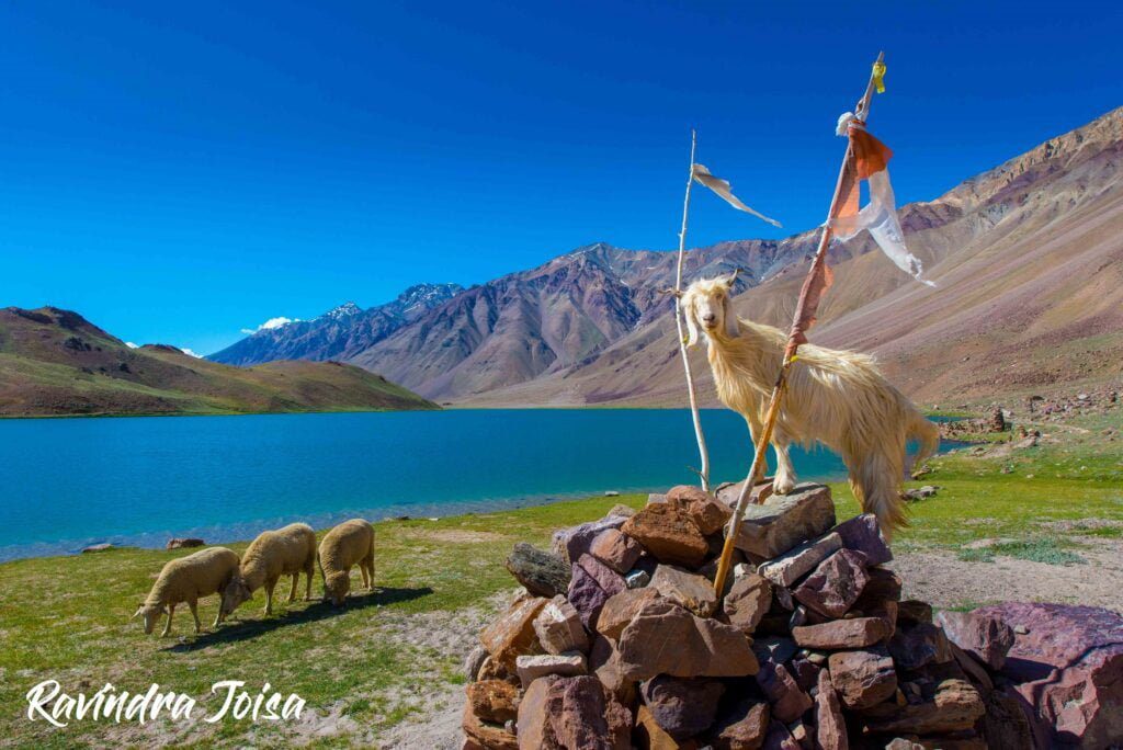
Chandratal is one of the most beautiful lakes located at an altitude of about 14,000 feet. Tso Chikgma or Lake of the Moon or Chandra Taal, or Chandratal is a lake in the Spiti part of the Lahul and Spiti district of Himachal Pradesh, India. The lake is near the source of the Chandra River. Moreover, it was designated as a world heritage site back in 2005. Despite the rugged and inhospitable surroundings at 4300 meters, it is in a protected niche with some flowers and wildlife in summer.

Why is Chandratal famous?

It was also a famous trading location for Tibetan and Ladakhi traders. The lake, with its wandering terrain typical of the secluded Spiti Valley, is a popular walking spot due to its mild climbing grade.

Himalayan Mountain Goat and sheep in front of Chandra Taal

How can I go to Chandratal lake?

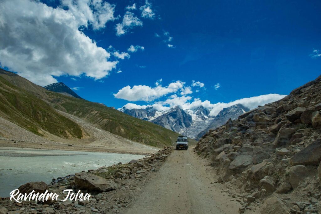
Batal is midway between Manali and Kaza. And a diversion from Batal will take you to the lake. Firstly, you can reach Chandratal from Manali which is about 110 kilometers drive. It takes about 2.5 hours non-stop via the new Atal Tunnel. Here the route is right next to the Chenab river. You can go via the famous Rothang Pass to make the drive more adventurous. Secondly, you can reach Chandra Taal from Kaza which is about the same distance and time. Here the route is right next to the Spiti river. On the way, you will be crossing the Kunzum La / Pass [video link].

What is the best time to visit Chandratal lake?

The paths to Chandratal Lake are available for a little more than 4 months, from the third week of June to the first week of November. However, the greatest time to visit Chandratal Lake is in September, when there is a good possibility of seeing flowering flora and wildlife, breathtaking terrain, and brilliant blue sky. During the following months, it will be blanketed in snow.

Dirt road drive from Manali to Chandra Taal next to river Chenab

Is camping allowed near Chandratal lake?

Can we stay at Chandratal lake? - Chandra Taal is a tourist destination for trekkers and campers. The lake is accessible on foot from Batal as well as from Kunzum Pass from late May to early October. There is also a motor road accessible as far as the parking lot, 1 kilometer from the lake. The lake is also accessible from Suraj Tal, 30 kilometers away. There are vast meadows on the banks of the lake. Expect these meadows to be full of wildflowers, during springtime.

We couldn't spend much time exploring the beautiful landscape as the only mode of transport did not want to drive back once it is dark. The place and surroundings have almost zero human habitation, with just a few campsites. The nearest fuel station or repair shops are a few hours of drive away and no one wants to take the risk of driving after dark on this dirt road. You may stay overnight at ChaCha - ChaChi Dabha or near Batal.

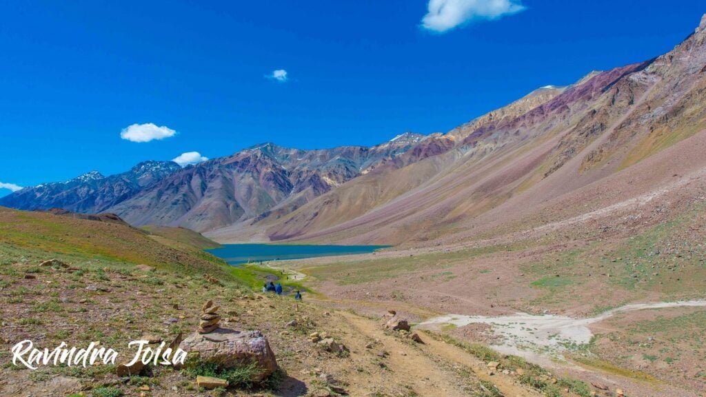
Final hike from the parking area to the Chandra Taal Lake, the first glimpse

Short hike just before the lake

You will not be able to drive all the way to the Chandratal. From the parking area, be ready for a short mile-long hike. I have been to this place twice. Firstly, after completing the last day of the Hampta Pass, on a clear day from the Chhatru campsite. Secondly, on the way to Kaza during the Kanomo Peak trek. Even though this mile-long hike is more of a flat walk, you can feel short of breath and is still in the high altitude danger zone. There are chances of getting altitude sickness as Chandratal is at 14,000 feet.

Ravindra Joisa at Chandra Taal

Why is Chandratal lake famous?

According to Hindu mythology, Chandratal is the location where Indra, the King of Gods, arrived in his chariot to carry Yudhishthira, the eldest of the five Pandavas, to Swarga in his mortal form (heaven). Fairies, according to locals, visit the lake at night.

Chandratal lake mystery

The glacier at Baralacha Pass is its source, but how the water gets from the glacier to the lake is a mystery in and of itself. Suraj Taal is said to be called after Bhaga, the son of the sun deity, and Chandratal after Chandra.

To conclude, even though the journey to this place is a bumpy drive on a dangerous mud road next to the Chenab river. The picturesque lake is worth the effort to reach this remote place. The landscape on the way is breathtaking. There are no stops to fuel your vehicle and just a few Dabhas to keep the hunger away. As of this writing, camping next to the lake is not allowed as per the new rules made by the government. This is to save the beautiful place from irresponsible tourists. The next place to visit around is the Kunzum pass.

Read Next: Mount Kanamo Basecamp High altitude Himalayan Trek

Also, check out my YouTube video of my visit to Chandra Taal lake and consider SUBSCRIBING to my channel to support my work.

https://youtu.be/h1rUVWy_JKc

Chatru - A beautiful Campsite in Lahaul valley | Hampta Pass Trek | Day 5

Day 5 of the Hampta Pass trek is from Shea Goru to Chhatru or Chatru campsite crossing the Chenab river. Trek to Chatru Himachal Pradesh from SheaGoru is a moderate 2-2.5 hours of walking on moraine and lose rocks on gentle inclines. This is followed by a descent to Chatru across a couple of glacial flows. As you move closer to the road, the descent gets a steep and little tricky. The last stretch is right next to the Chenab river and the trek ends next to the bridge.

Checkout previous day: Shea Goru via Hampta Pass | Hampta Pass Trek | Day 4

Shea Goru Campsite, at the time of sunset

Shea Goru Campsite

Even though Shea Goru campsite is just below the Hampta pass and in a valley, the evenings next to the stream can be beautiful. Golden hours can light up the snow cap mountains gold. The view of Mount Indrasan can be majestic from slightly above Shea Goru campsite. You can even spend the mornings and evenings with your legs dipped in the ice-cold stream. This is one of the most beautiful campsites of this entire trek. Also, you should feel great here as you have already crossed the Hampta Pass and is now at a viewable distance.

Crossing the ice cold stream

Our hike downhill on the next day starts with the crossing of an ice-cold stream, right next to the campsite. It is hard to cross the stream barefoot as there are sharp rocks underneath from the glacier above. From here it is a gradual descent, continuing to the valley below. By the way, we are now in the Lahaul and Spiti region of Himachal.

Lahaul Spiti Valley after Hampta Pass towards Chatru Campsite

The hike downhill towards Chatru

You will need to traverse the edges of rocks. Sometimes it might just be easier to get down into the river/glacier bed below to skip the rocky section and get back up. There are also a couple of places with slippery loose soil. Also, you get to see too many hiking trails here in the region. These are formed by the livestock raised by the locals. This section would take three hours when you are out of the mountains. You are still at a height but you have the road right across. The Chenab river separates you from the road. You can even see the vehicles appearing like a toy from here.

Himachal Public Bus from Kaza to Manali via Chatru campsite and the Chenab river below

Glacier View above Chatru

There are multiple huge glacial flows coming down from the mountains on the side of the Chenab river. Also, the view from this place of the glacier in front is breathtaking. Zoom in your camera to see the glacier in detail as shown in the image below. There isn't much human activity in this region other than a few shops which remain closed half the year. Moreover, the highway connecting Manali with Kaza has to be constructed every year because of the extreme weather.

The Glacier view as we hike downhill towards Chatru campsite

Where is Chatru located

Chatru is a green respite in the middle of the vast expanse of Himalayan snow. It is a little community of about 1000 people that serves as a stopover for several major hiking routes. The natural splendor of Chatru is beyond description. You may even start with the Hampta Pass trek from Chatru, cross the Hampta Pass on the second day, and then descend all the way to Manali valley by following the Rani Nala (stream) till you reach Jobra.

https://youtu.be/o3nNAmVfWZ4

Weather at Chatru campsite

Winter in this region is inhabitable and the roads remain closed. During the monsoon and summer, the Chenab river water level and the water current can be menacing. Continue to hike till you reach the bridge. You will find a few shops and dabhas here where you can have some hot tea and parathas. This is the Chatru village. You may camp here or go further to find some flat land to camp.

Where to stay in Chatru

The area is densely packed with Dabha and repair businesses. These stores even offer campgrounds within the Dabha where bikers and truck truckers may stay at a low price. If you continue on the road to Chandratal, you will come across some magnificent campsites where you may camp on your own next to some dabha or there are some decent pricey luxury campgrounds designed for visitors. These are temporary camps that will only exist over the summer.

Places to go in Lahaul Valley

Lahaul valley has some of the best landscapes and you will definitely love this place if you are a landscape photographer. If time permits then consider visiting the Chandratal (lake) and Kunzum Pass with incredible and stupendous views. You can plan to go to Leh from here. From Atal Tunnel instead of taking the tunnel road to Manali, continue further to Kelong and then to Leh.

https://youtu.be/h1rUVWy_JKc

To conclude, the last day of the hike can be much more relaxing as it is all downhill but can be exhausting as well as it is a long walk downhill. This is where you need to have a good pair of shoes else you can easily get blisters. Check out the video below and consider SUBSCRIBING to my YouTube channel.

Kibber Chicham Ropeway - An Extraordinary Canyon ride

Chicham - a remote village in the Himalayas in India. Spiti Valley is one of the world's most beautiful places on planet earth and has some stunning landscapes, lakes, canyons, glaciers, and snow cap mountains. As a result, adventure lovers flock around Spiti valley from all over the world. In addition, you will find a lot of bikers exploring this place.

There are these little know villages where a few families have lived for generations without any infrastructure or connectivity. However, the beauty of this place and the considerate nature of people make this place an ideal getaway. One such village is 'Chicham'.

Chicham village
Chicham Village as seen from the trail to Kanamo Base Camp. Image Copyright: Ravindra Joisa

How did I come to know this place?

Exploring the Himalayas is something that I love. Visiting a place that is less crowded, peaceful, and away from any kind of mobile connectivity is what I like. This time, the trek was not the usual trek. I usually go on a hike for a few days. But, this trek was a summit climb to Kanamo Peak which is at 19600 feet. And Kibber which is the village adjacent to Chicham is the basecamp.

Where is Chicham Bridge situated?

The nearest town to Kanamo is Kaza and the best place to collect all the ration needed for the trek. There is road connectivity to the basecamp, Kibber which is another village similar to Chicham. We reached Kibber a day in advance to get acclimatized to 14,000 feet. The only village around is Chicham which is more like a backyard to Kibber village.

Chicham and Kibber - Parilungbo canyon, Spiti valley
Parilungbo canyon and Kanamo peak to the top right. Image Copyright: Ravindra Joisa

What is Chicham Bridge famous for?

Which is the tallest bridge in Asia? - The tallest bridge in Asia may be seen in Spiti Valley. Yes, it is home to the Chicham Bridge, Asia's tallest bridge, and an amazing sight to behold. The bridge, which stands at a dizzying height of 13596 feet, is the highest bridge in Himachal joins the communities of Chicham and Kibber. The bridge was under construction at the time I visited this place and is now a major tourist attraction. The bridge has made the like of people living in these villages easier with better connectivity and an increase in tourism.

Spine-Chilling Chicham Ropeway

Chicham and Kibber had no connectivity before. Other than a round trip to Kaza, there is a Parilungbo canyon separating the two villages. So, the only way to reach Chicham from Kibber was to hike down to the Spiti river tributary and climb up. And, that would take half a day. This route was being used by the locals to carry heavy goods.

https://www.youtube.com/watch?v=JwIVbhLvGBM
Crossing Parilungbo Canyon using a simple ropeway.

But, locals without luggage had an alternative to cross the canyon with a self-propelled ropeway. Also called the Kibber Chicham Ropeway. There is absolutely no safety, but locals risked their lives to cross the canyon. Recently, the government has built a bridge connecting the two villages. During my visit, the Chicham bridge was under construction and I doubt if the ropeway still exists.

The ropeway has no backup power, motor, or any kind of safety and is completely manual. Luckily, in the video, you can see our trekking team pulling the rope. Also, the present-day Chicham bridge can be seen to the right in the video but was under construction at that time. So, if you have the guts needed to sit in that little cart and cross the canyon which is at a height of 150 meters, without any kind of safety gear then leave a comment.

https://youtu.be/vx41M7sxoOs

You might also like: KANJI – A REMOTE VILLAGE IN THE HIMALAYAS

Kanamo Peak which is approximately 19,600 feet high can be seen from these two villages. People stay at Kibber before making an attempt to climb the summit. The village stay is ideal if you are not acclimatized to this high altitude.

https://youtube.com/playlist?list=PLBtUUJUvar6qBtz1_EuRE7QhnTGYN-d0S

To conclude, this was a true adventure trip that I had and something that you should definitely experience. So, SUBSCRIBE to my YouTube channel and to my blog for more travel and photography stories. In addition, you can follow me on Instagram - @ravindra_joisa to see all my travel stories.